Monday, July 15, 2013

Sol 333: The One Kilometre Milestone

Since sol 329, Curiosity has driven an additional 44m approximately. That means it is now only a few metres away from hitting 1km of total distance covered for the first time in the mission. This is obviously an important milestone for a rover thats designed to go much further than any rover has gone before it. And the view is awesome as usual.
Sol 333 view after a 16m drive. Click for full size.
(NASA/JPL/Abraham Samma)
Looking at the panorama above and the map below, I estimated the sol 333 location as the place marked by a large white dot. We're on a south-west course heading straight for the ingress point. Can you match some of the features in the map to what you see in the panorama above?
NASA/JPL/UA/annotation by me

Saturday, July 13, 2013

Sol 332: Mount Sharp post haste

The rover's making extremely good progress towards the base of Mount Sharp. The strategy right now is to use a dune free area west of the rover's position which lies around 8 km away. Sprinting at least 20 m/day will get us to the 'ingress point' in around 400 days time. Plenty of time to allow us to soak in the ever changing scene as we make our way west.
Map showing Curiosity's progress up to sol 329 (NASA/JPL/UA)
To get out of the Glenelg quickly, the rover team employed the same route used to get into the area in November last year. And speaking of changing scenes, the rover has engaged in recent imaging with its MARDI image which hasn't seen much use since sol 176. If you remember, MARDI stands for 'Mars Descent Imager' which is located on the rover's front left underside. It captured spectacular images of Curiosity's descent towards the floor of Gale crater during landing last year in August.
Engineering diagram
showing where MARDI
is located (NASA/JPL)

Because it lacked a proper lens cover or similar protection like the other cameras it, MARDI's lens ended up covered in a fine layer of Martian dust kicked up by the rover's rocket-powered landing system and has since been producing hazy images. But now the decision has been to use the camera to document the changes in terrain texture. Images captured in twilight conditions have been shown to result in good contrast images without much light scattering from the dust coating the lens.
Two MARDI shots comparing the change in terrain
texture. From layered terrain to a rocky plain
(NASA/JPL/MSSS/Abraham Samma)
MAHLI is also being utilised for the same purpose. That seems to have been the only major activities this past week, interspersed with imaging with the colour Mastcams and long drives bordering 40m or so.
Sol 329 navigation mosaic showing Glenelg
and two sets of tracks. The right are new and
the left are old ones made last year leading
to Rocknest where Curiosity scooped
(NASA/JPL/Abraham Samma)
Finally, I'd like to share another brilliant video from JPL that summarises pretty much everything plus explains a little more about how Curiosity is making its towards the western ingress point. Enjoy and stay curious!

Monday, July 8, 2013

Sol 327: Shaler ops accomplished. Off to Mount Sharp!

It's now half past five in the evening of sol 327 of Curiosity's mission at Gale crater, Mars. Last week the rover was busy doing contact science on a rock called 'Shaler' with it's arm instruments.
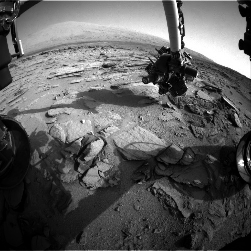
Front Hazard Avoidance Camera image
taken on sol 323 showing contact science
done on Shaler (NASA/JPL)
MAHLI image taken on sol 323 showing
Shaler's scalloped and pitted surface.
(NASA/JPL/MSSS) 
On sol 324, Curiosity switched to reverse gear and back up from Shaler.
Navigation camera image taken on sol 324
after the short reverse drive from Shaler
(NASA/JPL)
On sol 327 the rover performed another drive which takes it further down the path to Mount Sharp's base. It will take a long while (maybe even a year) to get to the mountain and that will depend on how many other targets Curiosity will have to check out that the science team find interesting. This ain't Formula One for sure!

The Mastcam's (the science cameras that attached to the top of the camera mast alongside the navigation cameras and the laser-shooting ChemCam) right eye (100 mm) was used on sol 323 to take wonderful shots of part of the dark dune field near the base of the mountain where you can also see layered rock exposures which might be contain the coveted clay minerals like smectite which usually form only in the presence of liquid water. I have stitched them into a mosaic. Click the mosaic to biggify!
Mastcam right eye mosaic showing part of the dark dune
that the rover team wishes to avoid and dark outcrop
exposures of ancient rock at the base of the mountain
(NASA/JPL/MSSS/mosaic by Abraham Samma)

Wednesday, July 3, 2013

Catching up on sol 322 (2.7.2013)

My, my what a busy month this has been for me! Fieldwork in the middle of nowhere and exams (and plenty more heading my way! Yikes!). But that's science for you. Tiring but always a joy to perform. Just like our intrepid rover and her hardworking team!
My colleagues and I in the town of
Mpwapwa central Tanzania posing for a shot
after completing medical fieldwork
(credit: Monica Shayo)
Speaking of which, this just leaves me with 34 sols worth of adventure to review! We last left her when she was wrapping up analytical work at the Cumberland work area.
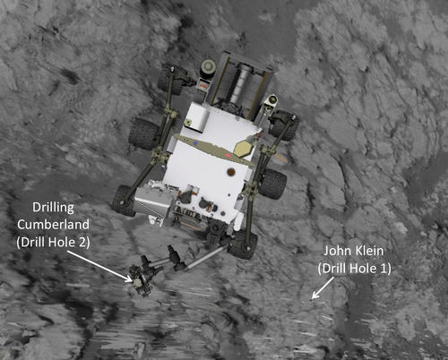
A computer model of Curiosity depicting its sol 274
 position next to Cumberland (NASA/JPL)
Afterwards, it was announced in a press release on June 6 that the team will now focus on long distance drives that will take the rover nearer to the mission's intended target; Mount Sharp aka Aeolis Mons. However that doesn't mean that all side shows will be ruled out for close examination. Anything that seems worth the time might be examined. Hence, it is difficult to tell when the rover will start treading the slopes of the mountain.

Departure from the Glenelg area took place on sol 295 starting with a 6.13m drive. Another drive followed 2 days later totaling almost 20m. The next few sols included lots of 2m drives up to sol 301 when the rover finally reached an intended target of investigation; Point Lake.
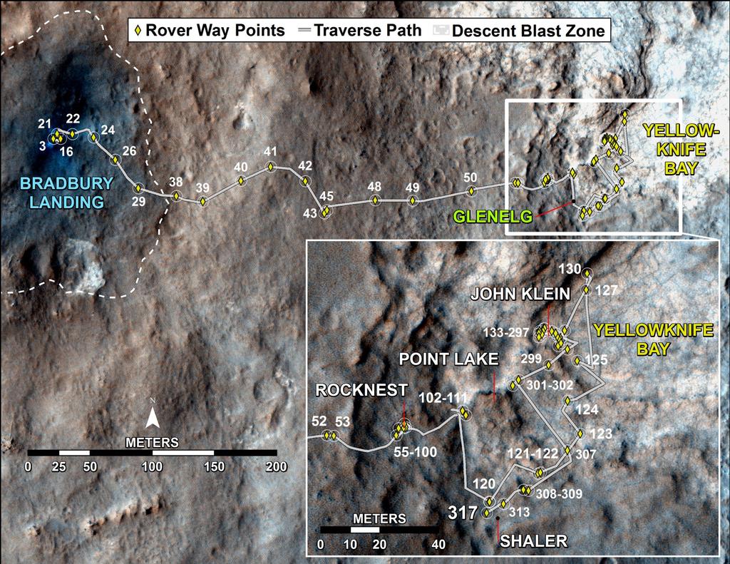
A map showing the progress made by Curiosity up to sol 317 (NASA/JPL/UA)
Point Lake is quite interesting because the rocks don't seem to be as straightforward as first impressions suggest. On the one hand the rocks contain holes, suggesting vesicular basalt rock i.e. igneous rocks. On the other hand there are signs that suggest a sedimentary history including raised rims in some of the holes and a cluster of pebbles at the bottom of the step-like outcrop that may be have been eroded out of the parent rocks, leaving the tell-tale holes.
Sol 317 navigation mosaic of Point Lake (the cliff-like outcrop to the left side) (NASA/JPL/mosaic by Abraham Samma)
The sedimentary picture becomes clearer at the bottom of the outcrop which seems to be softer than the upper portion of the outcrop. It could be basalt overlying sedimentary rock, who knows?
A mosaic showing details of Point Lake. The image has been
white balanced to make the scene appear as it would if it
were shot on Earth. The scale bars are 50cm. A full resolution version is here. (NASA/JPL/MSSS)
The next few sols were dedicated to arm work on the rover which was a little complicated because of the orientation of the outcrop. Nevertheless, the rover did manage to conduct excellent MAHLI imaging of the Point Lake rocks.
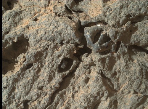
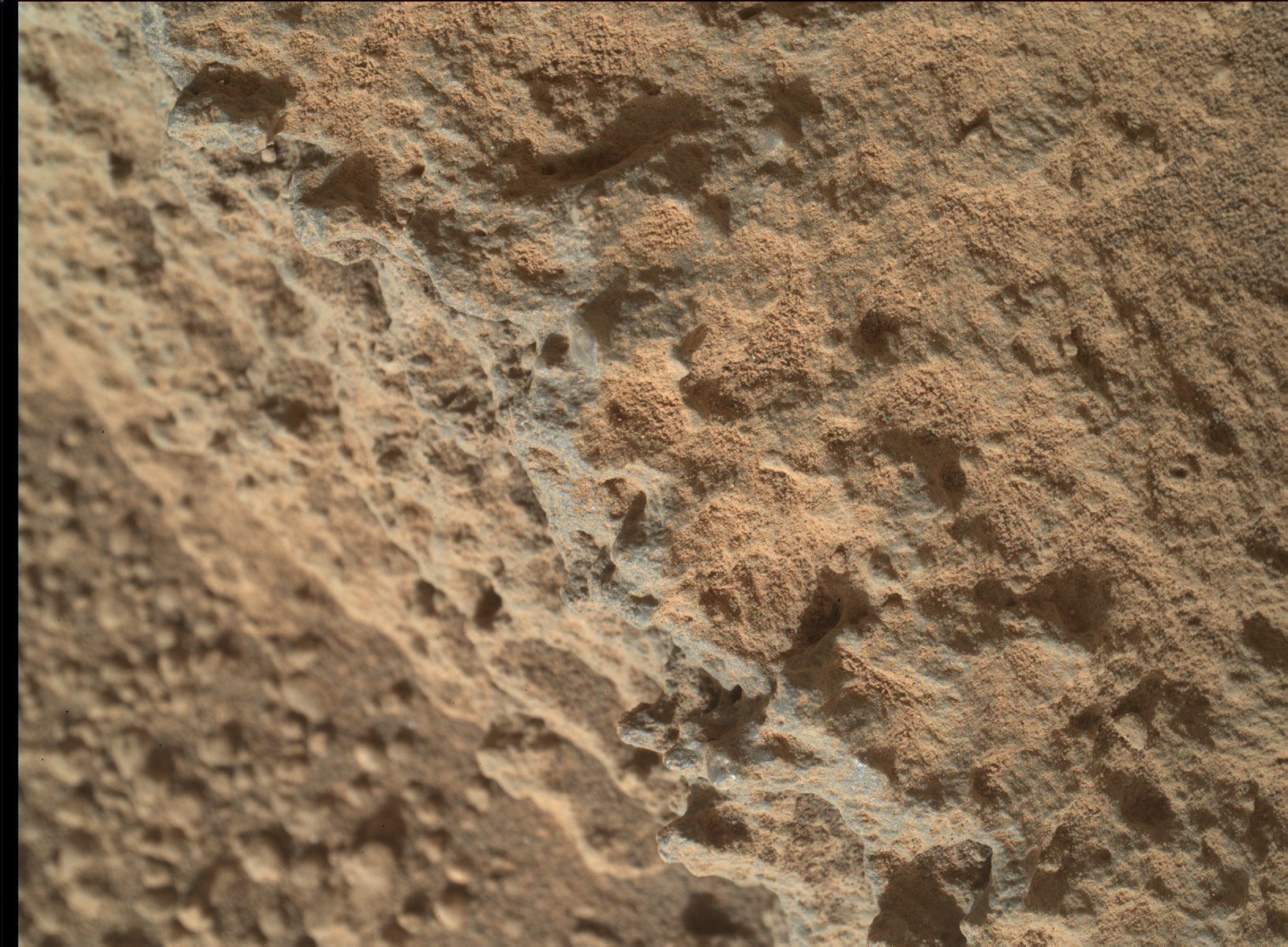
MAHLI image taken on sol 303. The lens of the camera was positioned
no closer than 15cm away from the rock face. Notice the holes some of
which appear to contain eroded out pebbles. (NASA/JPL/MSSS)
Afterwards, the rover logged around 68.65m and reached another outcrop called Shaler on sol 317 which is actually my personal favourite because of its fine layerings. It was passed over back then on sol 120 on the way to Yellowknife bay but now the science team appear to have reached a decision that Shaler requires more study.
A white balanced mosaic showing Shaler. The images were taken by the rover during sol 120 (NASA/JPL/MSSS)
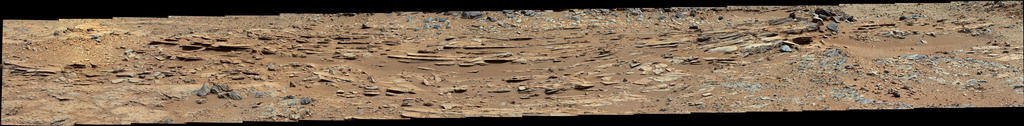
Sol 317 Mastcam left eye view of Shaler's layers (NASA/JPL/MSSS/mosaic by Abraham Samma)
Shaler is said to have more evidence to support the prevailing view that an ancient stream may have existed in the rover's immediate area of study in the remote past. So examining it now will definitely produce good science. Arm activity has been scheduled for the next few sols (though there could be one day of delay due to concerns about the rover's stability for arm deployment) including MAHLI imaging of Shaler which should be coming down even as I write this review. The APXS instrument will also be in use during this period. Shaler is expected to be the last stop before the rover starts trekking to the 'entry point' into Mount Sharp. The entry point lies a few kilometres away from the rover because the team wishes to avoid any unnecessary contact with the black sand dunes that hug the slopes of the mountain that may hamper the rover's progress if not hinder it completely.
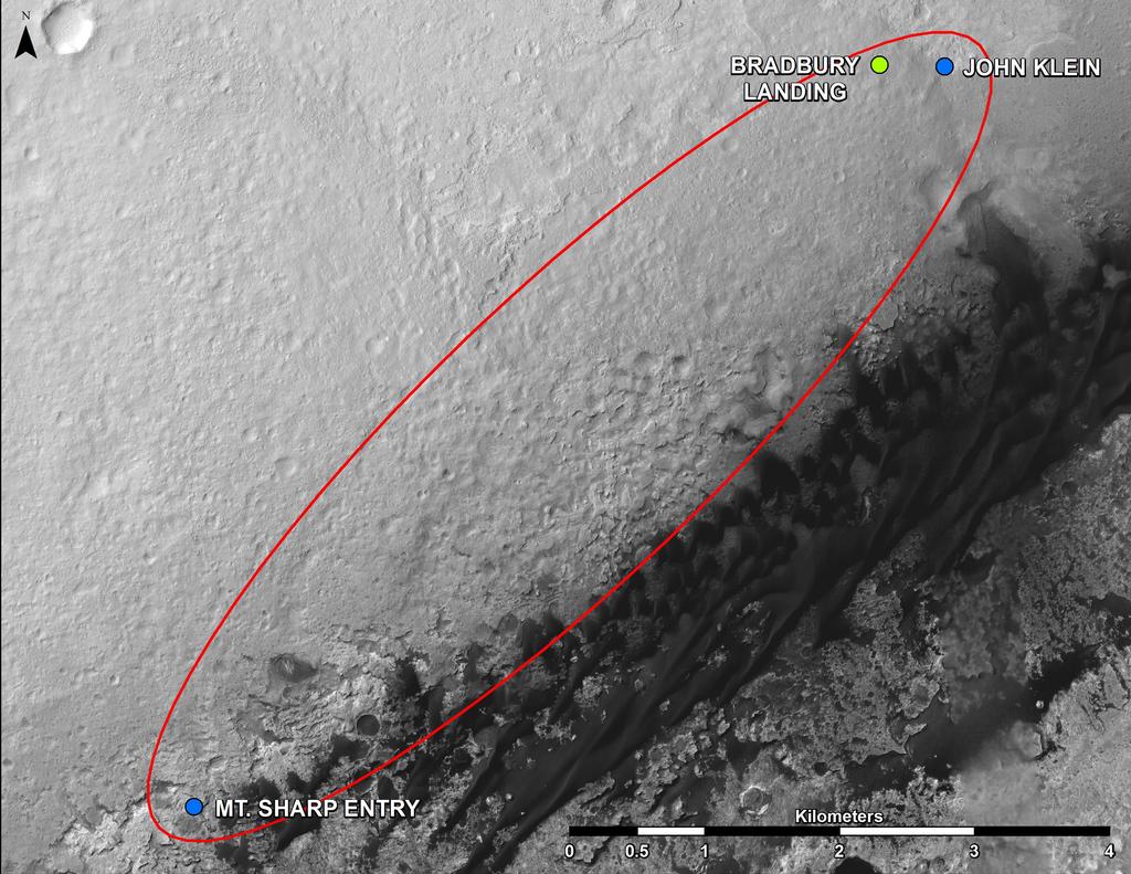
Orbital image from MRO's CTX imager showing the area (area within the red ellipse) Curiosity
will probably traverse before it gets to the entry point onto the slopes (NASA/JPL/UA)
And that's it I guess for the review. I've certainly gotten myself up to speed and I hope you have too dear readers. Stay curious!